The City of Clarence-Rockland has completed an Integrated Planning Act and Environmental Assessment Act Process in accordance with the Class Environmental Assessment (Class EA) to develop a Secondary Plan to be added to Section 8 of the Official Plan of the Urban Area for the City of Clarence-Rockland.
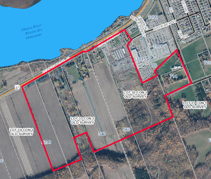
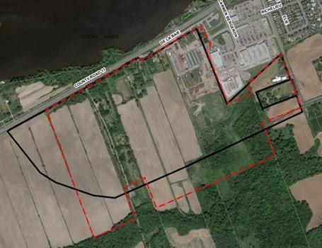
The study area consisted of the Rockland-West Secondary Plan lands, shown in the figure to the right. The area is located south of County Road 17 and west of Poupart Road. It was originally identified for development during the 2015 United Counties of Prescott-Russell Official Plan Review (the original boundary is outlined in black in the figure, and the current boundary is outlined in red). The Secondary Plan study assessed various land uses, transportation, and servicing infrastructure options for the Rockland West Secondary Plan lands to address growth in the region over the next 20+ years. It established a policy framework for the lands that will guide future development.
Municipal Class Environmental Assessment (MCEA) Process
The Secondary Plan was completed in accordance with the MCEA Master Planning process. The MCEA supports the planning and implementation of Municipal Infrastructure to be undertaken with an approved procedure designed to protect the environment. During this project, the MCEA process was completed in conjunction with the Planning Act. This allowed infrastructure planning under the MCEA process to be coordinated with land-use planning under the Planning Act.
A Master Plan is a long-range plan which integrates infrastructure requirements for existing and future land-use. The Master Plan was completed following Approach 1 of the MCEA Master Planning process and satisfies Phases 1 and 2 of the MCEA process. Individual projects identified in the Master Plan as preferred alternatives will require more detailed investigations at the project specific level to fulfil the MCEA requirements for the specific Schedule B and C projects identified prior to implementation.
Based on the study findings, input from technical agencies and the public, the Secondary Plan is now complete. The preferred alternative includes expansion of the City’s water distribution and sanitary collection systems, implementation of four stormwater management ponds, and constructing new streets within the lands with intersections to County Road 17, Poupart Side Road, and Richelieu Street. The recommended projects are presented in Section 9.1 of the Class EA Secondary Plan report which is available for review. [PDF/36.2MB]
Comments and Enquiries
By this notice, the Class Environmental Assessment component of the Secondary Plan is being placed on public record for a 30-day review period in accordance with the requirements of the Municipal Class EA. Interested persons may provide written comments to the project team by October 6th, 2024. All comments and concerns should be sent directly to:
Marc Rivet RPP, MCIP
Senior Planner
J.L. Richards & Associates Limited
864 Lady Ellen Place
Ottawa, Ontario K1Z 5M2
mrivet@jlrichards.ca
Marie-Eve Bélanger
Manager of Planning
City of Clarence-Rockland
1560 Laurier Street
Rockland, Ontario K4K 1P7
mbelanger@clarence-rockland.com
All personal information included in your request – such as name, address, telephone number and property location – is collected, under the authority of section 30 of the Environmental Assessment Act and is collected and maintained for the purpose of creating a record that is available to the general public. As this information is collected for the purpose of a public record, the protection of personal information provided in
the Freedom of Information and Protection of Privacy Act (FIPPA) does not apply (s.37). Personal information you submit will become part of a public record that is available to the general public unless you request that your personal information remain confidential.
If there is no request received by October 6th, 2024, the Class Environmental Assessment component of the Secondary Plan is deemed complete, and the City may then proceed with finalizing the Secondary Plan recommendations.
This Notice was originally issued on September 4th, 2024.